Election Information
This Statewide Special Election asks voters to approve or reject Proposition 50, which would amend the California Constitution to allow for the adoption of temporary U.S. Congressional District boundaries valid until 2031.
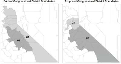
The new boundaries would be implemented immediately if the measure passes with a simple majority of voters statewide. If the measure passes, the proposed U.S. Congressional District for Mono County will change from Congressional District 03 to 05, which will be a shared district with Alpine, Amador, Calaveras, Inyo, Mariposa, Tuolumne, and part of El Dorado County.
All voters will be mailed a State Voter Information Guide from the California Secretary of State that will provide detailed information about the measure and maps of the proposed changes to the U.S. Congressional District boundaries for the State of California.
For additional information, please visit:
State Voter Information Guide:
Current Congressional District Boundaries:
Proposed Congressional District Boundaries:
- https://aelc.assembly.ca.gov/proposed-congressional-map
- https://leginfo.legislature.ca.gov/faces/billNavClient.xhtml?bill_id=202...
Proposition 50 |
|
| AUTHORIZES TEMPORARY CHANGES TO CONGRESSIONAL DISTRICT MAPS IN RESPONSE TO TEXAS' PARTISAN REDISTRICTING. LEGISLATIVE CONSTITUTIONAL AMENDMENT. | |
| Requires temporary use of new congressional district maps through 2030. Directs independent Citizens Redistricting Commission to resume enacting congressional district maps in 2031. Establishes policy supporting nonpartisan redistricting commissions nationwide. Fiscal Impact: One-time costs to counties of up to a few million dollars statewide to update election materials to reflect new congressional district maps. | |
| A YES vote on this measure means: The state would use new, legislatively drawn congressional district maps starting in 2026. California's new maps would be used until the California Citizens Redistricting Commission draws new maps following the 2030 U.S. Census. | A NO vote on this measure means: Current congressional district maps drawn by the California Citizens Redistricting Commission (Commission) would continue to be used in California until the Commission draws new maps following the 2030 U.S. Census. |


